Thursday, May 30, 2019

Argentina - On The Second Try

The Paso de Jama is the northernmost border connecting Chile to Argentina, it is also the highest altitude (legal) border crossing on the globe. The towns closest to the border, San Pedro de Atacama in Chile and Susques in Argentina, are separated by 165 miles of wilderness. The only habitation between them is at the border station, 103 miles from San Pedro and 3 miles inside Argentina. Chile and Argentina operate an integrated facility which proved to be very efficient, once I reached it on my second attempt.

My goal was to reach the reasonable sized town of Jujuy, nearly 300 miles from San Pedro. The road is paved the entire way and Google estimates a five and a half hour transit. Add an hour for the border formalities, so a decent length day was in prospect.

Monday I suited up to head to Argentina. It had been a very windy night and dust was still blowing through San Pedro as I headed out under an overcast sky. The local volcano was not sharing all her secrets.


It was blowing a steady 30mph with gusts up to 40 and  temperatures had dipped into the low 40'sF. Before heading up to the pass I plugged in my heated jacket and donned the heated gloves.

An hour into the journey temperatures had fallen below freezing, the wind intensified and the skies ahead looked ominous. At about the 50 mile mark, temperatures plummeted to 21ºF, sustained 50-60mph winds and a white out blizzard descended. Snow was accumulating on the road. A Connecticut Polar Bear Rider does not get fazed easily by winter conditions, but  at 15,500ft + on a remote road under those conditions the decision to turn back was an obvious one. 


An hour after I returned to San Pedro the authorities closed the border because of 'viento blanco', blizzards, and sustained gale force winds. While I was happy to be safely back at San Pedro, a mental gloom descended, I needed to get across the Andes to continue my journey. There are not many options to get into Argentina and those to the south for 1,000 miles were closed due to the same winter conditions. I didn't know if 24 hours would make a difference, but that was the most rational choice. 

Tuesday morning was a completely different day, calm under a full blue sky. The border normally opens at 8am, by 9am the government website still had a red light and boldly asserted 'CERRADO'. Finally at 9.05 it went green, 'ABIERTO'. I have never moved so quickly to pack up the bike.

The riding day could not have been better, temperatures stayed above freezing, the sky stayed blue. The wind was up at times but not the fierce blow of the day before. A little snow remained on the road in places, but most had been freeze dried under the action of dry air, low overnight temperatures and the incessant wind. 

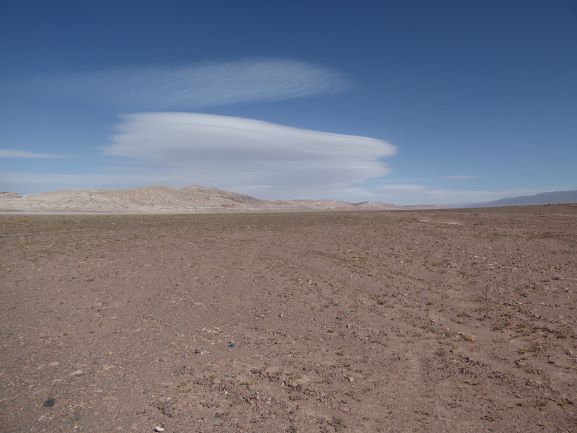
The scenery up at altitude was unworldly, the frustration and gloom of the day before vanished,  like the snow.


The views 1 minute into the video are on the Argentine side of the border. 


The Salar Grande in Argentina is not on the scale of the Salar de Uyuni but it is huge in its own right, and the color of the rock formations once descended from the high plains were staggering. 


The road down from the high plains was like a tormented piece of spaghetti, numerous switchbacks, steep descents and miles of it. A delightful way to bid the Andes farewell after weeks of incomparable motorcycling and tourism fun. The day peaked at 15,705ft, I will not see those altitudes again on this journey.

Jujuy was home for the night and then a short 60 mile ride to Salta today. Mist, a little rain and a road that twisted through verdant mountain forests reminded me of the Blue Ridge Parkway in Virginia. It was a pleasant change of pace.

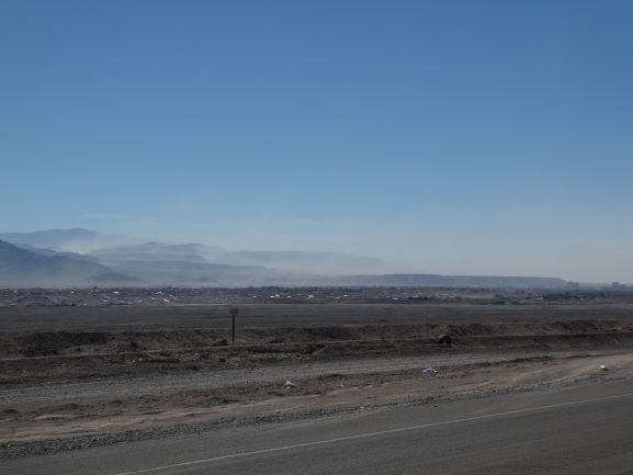
Salta is a town of contrasts, like many I suppose, some spiffy areas and others that perhaps illustrate the economic challenges that Argentina again faces. The spiffy pics.


Thursday the journey east commences in earnest, towards Corrientes. The nature of this trip is about to change, mountains are in the rear view mirror as I am heading for the Chaco region, a flat land, that is penetrated by a long straight road. Cattle country I believe.

I will catch up on the other side in a couple of days.

Cheers. T2


Monday, May 27, 2019

Three Days in the Atacama

Three days in the Atacama desert region began with the ride southwest to Antofagasta, a port and resort town. The journey was broken up with a visit to a railway museum in Baquedano. The museum is not curated and is tricky to find. A fascinating hour was spent wandering around a substantial steam locomotive depot, with several old locos still at shed. It was as if one day it was decided just to stop using them and they were left in place. Baquedano became a rail town in the late 1800’s to support the nitrate extraction industry and survives today as an active rail community still supporting mining, but now it is all focused on copper.


Antofagasta is at the heart of the northern Chile mining industry; a 4 day heavy equipment exhibition started on Sunday. It is also a coastal resort town. Seeing a sign, ‘pulpo parilla’, I immediately took advantage of the marine location; it was delicious and beat cuy hands down.


The next time the bike sees the Pacific will be in Patagonia, though the next ocean will be the Atlantic, my journey generally heads east from here.

The Mano del Desierto, the hand in the desert sculpture, is about 50 miles south of Antofagasta and was the motivation to make a return trip to the coast. It is a motorcycle adventure rider icon, a picture of the bike (and rider if possible) in the palm of the hand is on many bucket lists. Check.


Chacabuco was developed as a self-contained and walled mining town and is designated a national monument to the nitrate industry, the original source of wealth for Chile. It ceased operation in 1940 but was again put to use in 1973 as a concentration camp for political opponents of General Pinochet. It is on the way to San Pedro de Atacama and tweaked my curiosity.

Like the Baquedano rail museum Chacabuco does not appear to be actively curated, though there were some signs describing the site, in English too. The theater was quite grand in its time and evidently hosted Caruso back in the day when being in nitrates must have meant coining it.


 Apparently, the Guggenheim brothers were investors in the Chilean nitrate industry; think of that the next time you visit a gallery.
30 years after closing it must have been quite a desperate place to have been shuffled off too as a political prisoner in the hope you would be forgotten. One prisoner, Autor Orlando Valdese, left a permanent mark on the site, as did others, though with less artistic talent.


The Atacama desert carried a green hue to my surprise, a thin carpet of vegetation, some of which was in bloom. The area around San Pedro de Atacama is quite desolate, though the town has greenery. 


It is a young person’s town, hostels, cheap pizza restaurants and tour operators abound. The unmade streets, dusty in the gusty wind, add a rustic charm to the place and reminded me of some towns in the southwest USA. 


A not-so-cheap courtyard restaurant served up a good dinner, washed down with a couple of  beers of Patagonian origin. Chilled out is not a bad place to be.


 A couple of additional notes; during the three days I crossed the Tropic of Capricorn twice, once heading south and today when heading north. I will cross it again before this leg of the journey is over. El Burro has now surpassed 8,000 miles since leaving home in January.

Oh, and the wind was still blowing up a storm over the salar north of Calama. It must be the time of year. It is gusty now and the airborne dust is obscuring the volcanoes, I'm hoping it will be settled by morning.


Tomorrow a 300 mile haul to Jujuy, Argentina; country number 6 on this journey. Another salar to be crossed, paved this time.
T2


Sunday, May 26, 2019

Bolivia to Chile

140 miles on unmade roads, through remote country, awaits the overland traveler to reach Chile from Uyuni. Once across the border the nearest town is a further 120 miles through the Atacama desert, though the road is paved. There are no gas stations for 260 miles, a tienda or two along the way. It was never going to be a short nor an easy day.

While the Salar de Uyuni is the largest salt flat by far, numerous salars dot the region, more than I had realized. Like dried out rock pools - some small, some relatively large. Of the 140 miles to cover in Bolivia about 80 miles are on a salt flat. 

There are no specific roads on the flats, drivers make their own track, sometimes others follow to produce a more defined route.  In the rainy season the flats flood, as they dry out numerous tracks develop to avoid mud wallows. The rainy season ended about 6 weeks ago; the salar to the border was a mass of tracks at times, a clearly defined route was not yet obvious in places so picking a track to follow became the trick. 

When the wind blows over a dried out salar, salts, sand and dust are picked up creating mini sandstorms that last 5 or 10 minutes. You can see them coming, just like a squall line of rain. As I crossed the salar, which took 2-3 hours, a 40-50mph wind developed, visibility was near zero at times. No need to worry about other vehicles, I saw one pick-up truck in the far distance during the crossing. I don't recall ever feeling so isolated or vulnerable.

A momentary lapse of concentration during one of the sandstorm squalls and El Burro went earthbound. Slow speed, not even a bruise, but the front right turn signal snapped. In Colombia, Ecuador, Peru and Bolivia that wouldn't matter, useless equipment that no one uses; not so in Chile where their function is better understood.

It was dry and sunny though. Here is a sampler of the 140 miles.


A signpost on the salar.


I was happy to reach the border after 5½ hours, got stamped out by immigration very quickly, but Bolivian customs was at lunch. The office with the big 'Aduana' or customs sign, a door labeled 'Entrada' and cones to manage  the little traffic is not in fact where the customs people work, as I found out. Nope, they prefer another office in a scruffy little hut, another 30 minutes lost. The surly customs officer who eventually took the Temporary Vehicle Import Permit, that has to be turned in, did the paperwork in 2 minutes, though an hour plus had been consumed in total.

I was not the only overlander stuck in Bolivian customs confusion and delay. A Brazilian biker couple and a family in a camper van from Washington State enjoyed the proceedings in high winds, being blasted by sand.


One kilometer gets you into Chile. You know when you have arrived as tarmac greets the wheels. Unfortunately, when I arrived, Chile was having their late lunch break! It took another hour to be processed and get the moto paperwork. It was now nearly 4pm; 2 and a bit hours left of daylight for the 120 miles. 

On any other day, in any other place, that would be simple. The road was good but the wind was depositing Atacama sand on the roadway for the first 30 miles, 4-5 inches deep across the width of the road. Of course, at times visibility was not perfect so caution was needed. I stopped on a couple of  occasions to grab pictures.


It was volcano alley.

I finally reached Calama and my accommodation 30 minutes after sundown, to much relief, the reserve fuel light blinking. Showered and went for a Chinese dinner at a nice place a block away. 

It is a day I will remember. I slept well.

The following day was spent in Calama, thoroughly checking the bike over, doing the necessary repairs, cleaning the chain that was caked in grit and salt and so on. 

I noticed fork oil had oozed and gathered up dust sitting on top of the fork tubes. The road in Bolivia had been so rough it caused both lock nuts on the pre-load adjusters to back off, allowing oil to ooze out when the forks were under full compression. Never had that happen before and I have traveled some pretty rough roads on this and previous trips. A day to remember indeed. 

I enjoyed having a rest day and Chile is much more like home. Even had a Wendy's Baconator burger. Not Dave's best effort but it tasted damn good!

Then it was off to the Pacific Coast again, the final time on this leg.

T2

Friday, May 24, 2019

Salar de Uyuni - Images

No words needed.....


It was a privilege to experience the world's largest salar,,….and then we had time to goof around..


Bolivia was left behind on Wednesday, to be replaced by Chile, on what proved to be the longest and one of the most mentally and physically demanding days of the journey so far.

T2


Tuesday, May 21, 2019

Salar de Uyuni

When I first became interested in long distance adventure motorcycling some 9 years ago I developed a fascination for the Salar de Uyuni in Bolivia, A top ten bucket list was to put my wheels on the Salar; today it became a reality.

The 130 mile ride from Potosi to Uyuni was through perhaps the most varied of geologic landscapes  and colors I have experienced so far, then the awesome sight of the Salar came into view. There was never a doubt I would ride down and be physically on it.


The largest salt flat in the world provides an opportunity to goof around with your camera, which is exactly what I did.


As the video showed the salt flat is still wet, a recipe for problems if spray gets onto the bike, especially into the electrical wiring. It doesn't take long for corrosion to occur, so I just stayed at the entrance where all the tour operator vehicles had packed the surface.

I also took a ride down to the train cemetery in town, the graveyard for the locomotives and rolling stock that used to transport the minerals off the flats. 


Martin, from the Czech Republic, is traveling north from Tierra del Fuego. We swapped a few notes on his journey north and he gave me some good information on the road I am riding out to Chile come Wednesday. It is always nice to catch up with a kindred spirit.


On a note of curiosity, in Bolivia foreigners are charged 3x the subsidized price of gasoline that the locals enjoy. Passports have to be provided, data entered into a computer that gets authority back from La Paz. Well today when I went to get fuel the system was down. After waiting for a while the station owner said it was not going to get fixed anytime soon. I politely asked if he could fill the tank at the 'extranerjo' price and fill in the computer form with the details at a later date. He looked at me, rubbed his chin and told the attendant to fill me up, then charged me the local price....nice guy! As a foreigner obtaining gasoline 'sin factura' is rare.

Cheers. T2

Monday, May 20, 2019

Potosi, The Silver City

It was a short 100 mile hop from Sucre to Potosi. A familiar pattern, the road climbed and crossed the highplains, pleasant but unremarkable except for a very wide river valley of red sand and gravel that was being actively extracted. The valley was crossed by a foot bridge with a very elaborate buttress that was out of character with the area. I would dearly like to know the story behind it.


A rail line followed the road for many miles and in places the embankment had been washed away, it looked abandoned. So I was surprised to round a bend and see a motorail car with 3 men, pickaxes in hand, working on the line. The line looked no more in use after the work area than before. Make work?


Potosi exists for one reason and one reason only, silver and other minerals within Cerro Rico, a mountain that dominates the town physically and economically. It is a working town that greets the visitor with the largest gateway I have seen to date.


The Spaniards discovered silver in Cerro Rico in 1545, it has been mined ever since. The importance Spain attached to the town and the wealth accumulated is reflected in a well preserved center with impressive buildings that is crisscrossed with narrow paved streets. My hostel is in an antique courtyard home, tucked next to the cathedral.


But it is silver mining that remains the heartbeat of Potosi. One hundred mines still remove ore from the heart of Cerro Rico, employing 15,000 men directly and thousands more in the economic activity it generates. The mines are organized as co-operatives, each man essentially self employed. Several of the co-operatives offer tours of the working mines, an experience not to be missed.

After getting kitted up the first stop was the mine store, I had never seen dynamite before let alone a stick that was fused.


Then off to the mine head, drifted into the side of the mountain with galleries above and below the entrance level. The mine guard dogs demanded their tribute on the way in. Shortly after entering the mine a 2 ton cart of ore came hurtling along the tracks pushed by 2 men. A shallow recess provided a safe place to let it pass.


Two hours were spent underground; it was the most intense and at times frightening experience. Climbing 25ft ladders with missing rungs over an 80ft deep shaft, walking on a single rail, hands braced against the rock faces, a 10 foot fall awaiting the unwary, belly crawling through squeezes to access caverns where the vein of silver led the miners and where ore is removed to this day.  


 I was pleased to resurface and head back to town.

The center is lit up at night, making for a picturesque city setting that belies the conditions under which many of her citizens labor.


The journey continues Monday, 130 miles southwest to Uyuni.

T2.