Wednesday, February 27, 2019

Cordillera Negro

Heavy mist and cloud greeted me as the curtains were drawn in Huari at 7.30am, Tuesday. It is to be expected in a mountain town situated at over 10,000ft. Patience pays. By 9.30 the mist was lifting, peeks of blue sky suggested a nicer day ahead. The wheels started rolling at 10.

I was overly pessimistic in my attire and needed to stop to remove a layer while transiting the well paved valley road. After 30 miles the climb to cross the Cordillera Negro began in earnest. The range acquired this name as the mountains are not as high, snow not nearly as prevalent. Still, an altitude of 14,500ft at the continental divide is not too shabby. A cold rain fell on the Atlantic side and required putting the layer back on. Emerging from the tunnel on the Pacific side the road was dry, only a few spots of precipitation hit the visor. The chill remained.

As has frequently been the case each side of the mountain range has different weather. It is always nicer to go from wet to dry.

Rain returned as I entered Huaraz, home for the night and another town at over 10,000ft. The hotels are not heated and it gets cold at night at these altitudes. Under Armour cold gear makes great sleep wear!

Many of the towns in the Andes have had a pulse, a few have not; Huaraz has a heartbeat. Bigger in size and a 'hot' tourist town for adventurers in the northern hemisphere summer, the town has a raft of restaurants serving more than fried food with rice. Cerviche took my fancy, it was a pleasant change of pace.

The Cordillera Negro in a video collage.


T2

Tuesday, February 26, 2019

Cordillera Blanca

Caraz was home for the night, February 22nd. Shortly after checking in to the hotel I met Guliver Rojas. Guliver, a well traveled Peruvian, had recently returned from time in South Bend, Indiana and was being joined by his brother, Cristian, and sister-in-law, Isobel for some sightseeing. They invited me to join them on Saturday to visit Laguna Langanuco in the Cordilleras, I gratefully accepted.


To get to the lake you pass through Yungay, another town in the Andes that suffered tragic loss of life after being inundated by a snow, rock and earth avalanche triggered by the Ancash earthquake,  May 31, 1970.  Pictured above are the twisted remains of a bus caught in the landslide, the floor points skywards, the cab buried. Over 20,000 people lost theirs lives in Yungay, many of whom remain buried under the slide, the site has been declared a national cemetery. More pictures of the lake appear in the video.

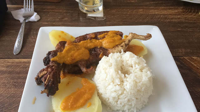
Saturday was also the day I tried cuy (koo-ee), guinea pig, in a picante sauce. It tasted fine but was a lot of effort for very little meat, Guliver informed me that it is very protein rich. It is my belief I disappointed my hosts by not spending more time nibbling, guinea pig like, at the bones.


Departing Caraz on Sunday for Huari required crossing the Cordillera Blanca range. Approaching the range the skies parted to capture a picture of Huascarán, the highest peak in Peru, and the sister peak at left.


When the GPS looks like this you know that fun lies ahead, especially on a well paved road, like the 107.


The other rider in the picture is California Chad on his Honda Africa Twin, I met him the prior day and again on Sunday as I was ascending the Cordillera. We stopped and chatted a while.

The road peaks at 15,538 ft, the tunnel is on the continental divide, the picture taken on the Pacific side. There were a couple of local riders at the tunnel.


The clouds lifted on the Atlantic side, the views were stunning, the road made for two wheels. It was the best couple of hours of the trip so far.


A lunch stop in Chacas and then the second 60 miles of the day to Huari, though on an unmade rocky and muddy road made more interesting with periods of heavy rain, thunder and lightening. That was the price for the day, but the pay off was worth every drop of rain.

More views of the two days in the video below.


A short clip as seen from the cockpit.


Hanging in Huari for the day, a working rather than a tourist town. Rest up and catch up before making two more crossings of the Cordillera, tomorrow from east to west and the final one west to east as I meander to Huánuco arriving on Friday. The bike will be parked there for the time I return home.

All for now, T2. 

Monday, February 25, 2019

The High Roads

Thursday was a bit of a washout. After leaving Cajabamba a decision was needed about 30 miles out of town; take the high mountain pass to Pallasca or continue down to the Pacific coast? Thunder, lightening and torrential rain made the decision to proceed to the coast an easy one. The high road was not a rational choice.

Peru is known for its mineral wealth and before the rain came the sight of a massive mountain top removal project revealed itself. Gold and copper are extracted from this mining operation.


Trujillo is  home to several pre-Inca archaeological sites, I passed by one but did not visit. The priority for the balance of the day was to get the gear dried out and retire early, hoping that a sullen mood and the cloudy skies would both be lifted by morning.


An early start under bright skies and dry, fast pavement on the Panamerican highway that runs down the coast delivered a boost to my spirits and moved me 70 miles south to the town of Santa by 9am. The coast of Peru is mostly desert, though irrigated and farmed in places. The change of scenery was also welcome; an overnight stay in Trujillo was the right medicine.


Breakfast was taken a a juice bar in Santa where I met the three fellas in the picture below. Miguel, Tupac (an Inca name, not a US rapper musician) and the guy at right, whose name escapes me, who introduced himself in Japanese! He was floored when I responded in nihongo myself, having spent a lot of business time in Japan. Miguel is running for mayor of the town, he gave me one of his campaign badges and I believe I am eligible to vote. Our conversation was held variously in Spanish, English and Japanese. The girls behind the counter were bemused by it all.


Leaving Santa on route 12 the road gently rises through a fertile valley in an otherwise arid landscape.


Route 12 eventually merges with route 3N, the point where I would have emerged the day before over the high pass; this area is known at Caňon del Pato; the Canyon of the Ducks. The road required the construction of 35 tunnels, some modest others more substantial. As the road climbs the canyon narrows and greenery starts to appear. The ducks were not much in evidence, food for the construction workers I fear, never to return.


The light can just be seen at the end of the tunnel.


The next two nights were spent in the town of Caraz exploring and riding through the Cordillera Blanca. The area has been described by others using grandiose terms; it did not disappoint.

Cheers. T2


Thursday, February 21, 2019

Ride The Peruvian Andes.

Rain. Cloud. Sun. Twists. Turns. Motorcycle nirvana.

Material poverty; wealth of beauty.


Part 1


Part 2


Cheers T2


Wednesday, February 20, 2019

Sun and Sols

Monday, for the fifth day in a row, I suited up. The day delivered an assortment of experiences, all good.

Heading down from Chachapoyas a left turn yields to the valley of the Rio Utcubamba, which was running swiftly. A nice relaxing and flat ride through a pastoral setting. A bridge built of blocks of stone with decorative work made a nice change from the usual concrete and steel rail structures. 


Eventually, the road took to the hills and at Leyembamba, home of a Mummy museum, the road was closed. Rain was passing through and I was told that the road would not open until 2 pm, it was 10.30. Or I could take the marked detour to Balsas, though the roads were not visible on my GPS. An hour or two in the museum seemed a better option at the time.

The museum held artifacts and displays from the pre-Inca era, including the mummies of the deceased, some of whom died from blows to the head. Apparently, the local tribe was quite fierce!


The staff asked where I was headed. Fortunately, after saying I was waiting until 2pm for the road to open I understood the response; it often didn't open until 4 or 4.30. That would put me in a bad spot timing wise. They told me to ..'take the detour!'.  They explained that the first 10km were a little rough but it was a good road, advised on the turns to take .....and commented that the views were better anyway. I would get to Balsas around by 4pm and to Celendin, my destination by 6pm.

The decision was made and they were right on every count.


In the high mountains the temperatures dropped to the low 50'sF, in the valley over 102F. Two valleys, two mountain ranges crossed. The pictures speak for themselves. It was a full 10 hour day.

I arrived in Celendin about the expected time but was having trouble locating the hotel. After asking a couple of times the third time was a charm. Three ladies playing cards had their game interrupted, one of whom gave me directions and then said "...that is my moto you are parked next to, I will lead you there" how nice was that!

Celendin has been home for two nights. The hotel is very comfortable, and the town is clean. The cost of the stay 40 sols, about $13 per night. No reason to camp at that price.


I may have found the ex-racing guinea pigs. They don't look that nice when cooked, worse when raw. Nice of them to leave the major organs in, the best part!

Sidewalks in Peru are often raised a foot or more above the road; now I understand why. Perhaps it is drainage or more relevant to have a seat while sharing the gossip. The hats have changed from up north. Is there significance to the change? I can't seem to ask the correct question to get the answer.


Back to business tomorrow.

Cheers. T2

Monday, February 18, 2019

Peruvian Gifts

The border crossing from Ecuador to Peru on Saturday was a simple and speedy affair. It only took 10 minutes to get stamped out of Ecuador and 45 minutes to complete the formalities to enter Peru.

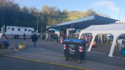
It is a bit of a backwater crossing as the picture shows. Immigration is in the portakabin. Peru was only marginally more modern.


Peru is know to have some interesting driving habits. My experience of this came quickly in a town called Tambo Grande, a dusty, dirty place. At a stop light the pick-up in front of me decides that he needs to reverse to change lanes, with no where to go I just hollered and hooted to get him to stop, which he did but not before riding up on the front wheel and wrecking the fender. The mounts were twisted like fusilli pasta, the fender busted. Fortunately, that was the limit of the damage, the bike handles as it should.

Once at the hostel for the night I concocted a web of zip ties to hold the rear part in place to avoid getting coated in road muck and to protect the radiator.


The day did not get better, shortly after leaving town I was confronted with a 40ft wide water crossing, the concrete crossing bed was coated with slimy algae, the water flowing briskly. Though approached gingerly the front wheel lost traction and that is never a positive, I inspected the slime more closely than I desired. A slow speed spill in water that did no damage to me and only a few (more) scrapes on El Burro.

I rode for another 100 miles and called it a day at Olmos; the hotel had a small pool, my second but more pleasant dunk of the day. Sunday could only get better. It did.

The ride to Chachapoyas up in the Andean hills was a delight. The sun shone, the road twisted up and down, a good surface and the views reminded me of why I decided to come. The frustrations of Saturday washed away. These are the Peruvian gifts I came for.


Though one must never get lost in the moment.


Onward.

T2


Saturday, February 16, 2019

Nariz del Diablo

Two nights were spent in Alausi, the first day gave time to chill out, get the bike cleaned up and thoroughly check it over. However, the real purpose of going to Alausi was to take the Tren Ecuador ride on the Nariz del Diablo line; the Devil's Nose excursion. Scottish engineers planned and built the line that established a rail link across the Andes. Such is the topography that two switchbacks were needed to cope. Over 2,500 men died in the construction of the line and while it makes for a spectacular tourist attraction one has to doubt it was worth the human price. There was no information on whether the line was ever commercially successful; I have my doubts.

The turnaround point featured a museum depicting the way of life of the local peoples, some of whom put on traditional dancing; not my usual gig but quite well done.

The 8.00am excursion returned to Alausi at 10.30am, at which point I hopped on the bike and headed the 100 miles south to Cuenca. Cuenca proved to be an interesting and spotlessly clean town, or at least the old center was. The town hosts the usual collection of Spanish colonial buildings but is also modernizing with a new tram system planned to open next month. One of the trams moved through the center on a test run while I sat people watching.
.
Today, Friday 15th, was a long day in the saddle with a 240 mile, 6+ hour ride through a partially sunny (and importantly for a change, dry) mountain-scape. The destination being Macara, a border town and the tee-up to cross into Peru tomorrow.

Passed a couple of milestones today; the wheels have rolled for over 3,000 miles since leaving home on Jan 5th and I was required to stop for the first time and show documentation at an Ecuadorian Army checkpoint about 25 miles north of the Peru border. Peru is a big producer of coca paste and it travels north to Colombia. Ecuador is not so keen on that. The stop was brief and very courteous and conducted entirely in Spanish. My linguistic skills must improving or they didn't understand a word I said and couldn't be bothered with a Gringo; I hope it was the former. The commander approved of the picture being taken.


Wifi internet connections from rural Peru can be fickle, so the frequency and content of posts may decline, which for some might be a blessing!

T2


Thursday, February 14, 2019

Volcanic Activity

Ecuador is home to a number of volcanos, both active and dormant, along with the geological marks that volcanic activity leaves behind. Travel on Monday and Tuesday was organized to experience this aspect of the country.

Leaving Quito and heading south, Cotopaxi, perhaps the most famous of the active volcanos in Ecuador should appear to the east. It didn't. The morning ride was a mess of rain, fog and low cloud. Cotopaxi kept her secrets from me, even the base was obscured. Not the start I had hoped for.

Not totally discouraged I continued on to Lake Quilitoa, or Crater lake  as it is more commonly known to English speakers. The approach to the lake was not very encouraging, but on arrival the clouds lifted, a few breaks of blue appeared as did the lake in all its splendor.


The lake is about 3km wide and formed in the caldera of a volcano that last erupted in 1280. The water is green in color from the dissolved minerals. Selfies are not my usual gig, but this one was taken about half way down a very steep path to the lake shore and I thought worth posting. At about 12,000 ft the air is pretty thin, the motorcycle clothing heavy and hot and the lungs (or knees for that matter) had limited capacity to make the return; I went no further. Evidently a burro ride back to the top is $10. They could charge more, anyway, one burro on this trip is enough.

After a night in Pujili, a small, pleasant town, I made my way to Alausi with a detour through Chimborazo park to try and spot the highest peak in Ecuador (20,564ft) and the dormant volcano after which the park is named. The peak showed itself briefly from the north, and again looking east as the road curved around.


I topped out at 14,407ft, it is pretty lonely up there and is desert  as the pictures show. A couple of cars and groups of vicunas were the only company. The wind was pretty stiff and chilly.


A day off the bike today except to gas up and get it washed. Chain maintenance, electrical system function check,  check bolts are tight and so forth; all seems in order. Boots cleaned, some laundry and a wander around the village filled the day. A ride on el Tren Ecuador, Nariz del Diablo, the Devil's Nose line awaits on Thursday morning. Then onward to Cuenca, a hotbed of American expats stretching their retirement dollars.

It is starting to feel and look like the Andes.


Cheers T2


Monday, February 11, 2019

Ecuador . The Story So Far .


It is fair to say that crossing the border from Colombia into Ecuador created some anxiety. It proved needless, my experience did not replicate reports of hours spent navigating the bureaucracy of changing countries. Passage was complete within an hour, by 7.15am I was rolling towards Tulcan. Arriving at the border at 6am certainly helped, by 7am the refugees from Venezuela had started to appear in increasing numbers.

Tulcan is famous for the topiary in the cemetery, making it something of a tourist destination. As early as I was the place was deathly quiet.


The night was spent at Ibarra, at a hotel located on the volcanic lake, Yahuarcocha. The journey south continued the following day with a stop at Otavalo to witness the indigenous market for which the region is noted. Colorful people with colorful food available.


About twenty miles south of Otavalo is the Equator, marked by a monument and sun dial. The sun dial reflects the importance of the location to the peoples that populated the area 500 years prior to the arrival of the Incas. It was not to be missed.


Navigating to the hotel on the outskirts of old town Quito went without a hitch, where I met a couple of Brits from Hereford. Well into their 70’s, they assembled a travel itinerary to spend a month in Ecuador; backpacking, hiking and moving around on public transport. Good for them!
The bike remained parked on Sunday, a 25 cent bus ride and old town Quito provided entertainment. Unlike cities back in the US, which empty out at the weekend, Quito old town was a bustle though not quite on the scale of Bogota.

It was quiet when I arrived at 9.30am and climbed the towers of the Basilica; by 10.30am the locals started to arrive in numbers, though the Presidential Guards were unfazed.


Quito is a city built in the Andes, the topography is on display in the video. The center is well preserved; Spanish colonial and attractive. The first sweep is looking south, the second to the north, where the towers mark the new town and business center of the city.
The Ecuadorians love their chocolate and the quality of cocoa produced is a matter of pride. Yumbos chocolate is a cooperative outlet for fine beans grown on small scale farms often owned by women. The Molinari chocolate shown is produced in limited quantities from beans sourced from a single estate, it is considered the ‘Grand Cru’ in the chocolate world. It was indeed “Chocolate Sabroso” – the title of the track used on the video. 


The journey continues tomorrow, the bike being newly badged.


T2.